
Exploring India's Digital Earth from Space
Introduction
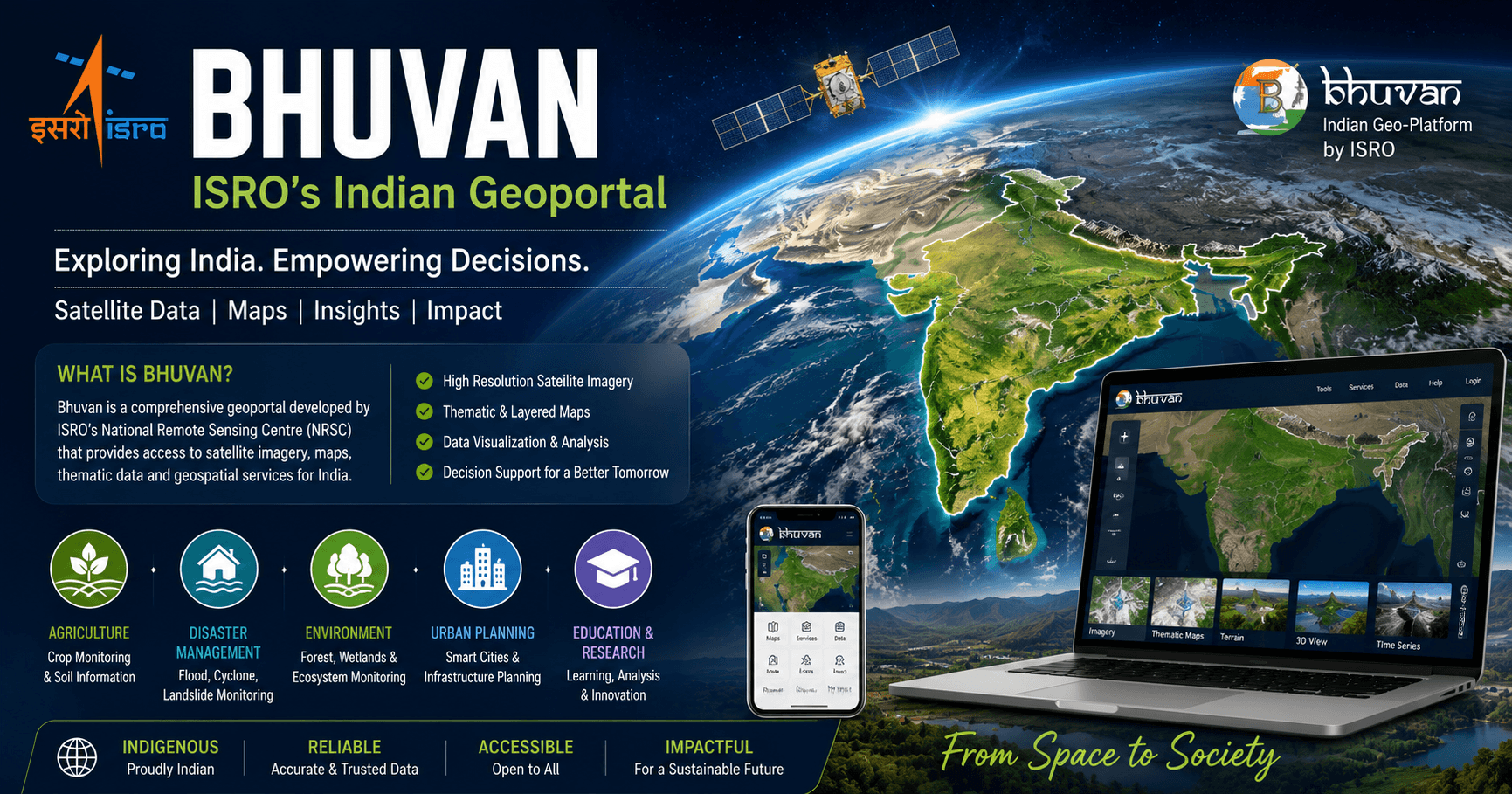
Imagine accessing high-resolution satellite imagery, mapping natural resources, tracking disasters, monitoring agriculture, and exploring India's landscapes—all from a single platform developed by the Indian Space Research Organisation (ISRO). That's exactly what Bhuvan – ISRO's Indian Geoportal offers.
Often described as India's answer to global mapping platforms, Bhuvan is much more than a digital map. It is a comprehensive geo-information platform that provides satellite imagery, thematic maps, geospatial data, and decision-support tools for government agencies, researchers, students, businesses, and the general public.
In this article, we'll explore what Bhuvan is, its key features, applications, benefits, technologies, and why it has become one of India's most valuable geospatial platforms.
What is Bhuvan – Indian Geoportal of ISRO?
Bhuvan is a web-based geospatial platform developed by the National Remote Sensing Centre (NRSC), a key center of the Indian Space Research Organisation (ISRO). It enables users to access and analyze satellite imagery, maps, and location-based information related to India.
Launched in 2009, Bhuvan was designed to provide an indigenous alternative for accessing India's geospatial data with greater focus on local accuracy and public utility.
Unlike traditional online maps that primarily emphasize navigation, Bhuvan provides specialized datasets that support environmental monitoring, disaster management, urban planning, agriculture, water resources, forestry, and scientific research.
History of Bhuvan Geoportal
India has long invested in Earth observation satellites and remote sensing technology. To make this valuable satellite data accessible, ISRO developed Bhuvan as a national geospatial platform.
Major Milestones
- 2009 – Bhuvan officially launched.
- Expanded satellite imagery and map layers over subsequent years.
- Added disaster management services and thematic datasets.
- Integrated village-level information and government projects.
- Enhanced web services, mobile access, and data-sharing capabilities.
Today, Bhuvan serves millions of users ranging from government departments to students and GIS professionals.
Key Features of Bhuvan Geoportal
1. High-Resolution Satellite Imagery
One of Bhuvan's biggest strengths is access to high-quality satellite imagery captured by ISRO's Earth observation satellites.
Users can explore:
- Cities
- Villages
- Rivers
- Forests
- Mountains
- Coastal regions
- Agricultural land
The imagery is continuously updated to improve accuracy and usability.
2. Interactive Digital Maps
Bhuvan offers multiple map layers, including:
- Administrative boundaries
- Roads
- Railways
- Rivers
- Water bodies
- Elevation maps
- Land-use maps
- Terrain information
These layers help users analyze geographic information more effectively.
3. Thematic Mapping
Unlike ordinary map services, Bhuvan specializes in thematic datasets such as:
- Land use and land cover
- Agriculture
- Forest cover
- Soil information
- Watersheds
- Groundwater resources
- Urban development
- Climate-related datasets
These maps support planning and decision-making across various sectors.
4. Disaster Management Support
Bhuvan plays a vital role during natural disasters.
It provides near real-time information for:
- Flood monitoring
- Cyclone impact assessment
- Landslides
- Forest fires
- Drought analysis
- Earthquake response
Government agencies use this information to improve emergency planning and relief efforts.
5. 3D Visualization
Users can visualize terrain and landscapes in three dimensions, making it easier to understand geographical features such as mountains, valleys, and river systems.
Applications of Bhuvan
Agriculture
Farmers, researchers, and policymakers use Bhuvan for:
- Crop monitoring
- Irrigation planning
- Soil analysis
- Drought assessment
- Agricultural productivity studies
Urban Planning
Urban planners rely on Bhuvan to:
- Monitor city expansion
- Plan infrastructure
- Manage land resources
- Analyze transportation networks
- Support smart city initiatives
Water Resources Management
The platform assists in:
- River basin management
- Watershed development
- Reservoir monitoring
- Groundwater mapping
- Floodplain analysis
Environmental Conservation
Environmental agencies use Bhuvan to monitor:
- Forest cover changes
- Wildlife habitats
- Wetlands
- Coastal ecosystems
- Pollution-prone areas
Education and Research
Students, universities, and researchers use Bhuvan for:
- GIS learning
- Remote sensing projects
- Environmental studies
- Geography education
- Scientific research
Technologies Behind Bhuvan
Bhuvan combines multiple advanced technologies to deliver accurate geospatial information.
Remote Sensing
Satellite sensors capture detailed information about Earth's surface without direct contact.
Geographic Information System (GIS)
GIS technology allows users to analyze, visualize, and interpret spatial data effectively.
Earth Observation Satellites
Bhuvan integrates data from ISRO's Earth observation satellite missions, enabling continuous monitoring of natural and human-made features.
Web GIS
Through modern web technologies, Bhuvan delivers interactive maps and geospatial tools directly to users via standard web browsers.
Benefits of Using Bhuvan
Bhuvan offers several advantages:
- Developed specifically for India's geographic needs.
- Access to reliable satellite-based information.
- Supports government planning and governance.
- Valuable resource for researchers and students.
- Improves disaster preparedness and response.
- Encourages evidence-based decision-making.
- Promotes indigenous geospatial technology.
Bhuvan vs Global Mapping Platforms
FeatureBhuvanTypical Global Mapping PlatformsDeveloped byISRO (India)International technology companiesPrimary FocusGeospatial analysis, remote sensing, thematic mappingNavigation and general mappingSatellite DataISRO Earth observation missionsMixed commercial and public sourcesGovernment DatasetsExtensive India-specific datasetsLimited government integrationDisaster ApplicationsStrong focusGeneral supportResearch ToolsAdvanced geospatial resourcesBasic mapping features
Rather than replacing global map services, Bhuvan complements them by offering specialized geospatial information tailored to India's needs.
Challenges and Future Opportunities
While Bhuvan has made significant progress, there are opportunities for further enhancement.
Challenges
- Increasing public awareness.
- Simplifying advanced GIS tools for beginners.
- Faster updates for certain datasets.
- Broader integration with emerging technologies.
Future Opportunities
The future of Bhuvan looks promising with potential advancements such as:
- Artificial Intelligence (AI)-powered geospatial analytics.
- Machine Learning for land-use classification.
- Enhanced 3D mapping and visualization.
- Improved mobile accessibility.
- Real-time satellite data integration.
- Expanded support for climate change monitoring.
- Greater collaboration with government and academic institutions.
These innovations could make Bhuvan an even more powerful platform for digital governance, scientific research, and sustainable development.
Frequently Asked Questions (FAQs)
What is Bhuvan?
Bhuvan is a web-based geoportal developed by ISRO that provides satellite imagery, maps, geospatial data, and analytical tools for India.
Who developed Bhuvan?
Bhuvan was developed by the National Remote Sensing Centre (NRSC) under the Indian Space Research Organisation (ISRO).
Is Bhuvan free to use?
Many of Bhuvan's maps, datasets, and services are freely accessible for public use, while some specialized data may have access conditions depending on the dataset.
How is Bhuvan different from regular online maps?
Unlike navigation-focused mapping services, Bhuvan emphasizes remote sensing, thematic mapping, environmental monitoring, disaster management, and geospatial analysis.
Who can use Bhuvan?
Bhuvan is useful for students, researchers, government agencies, planners, businesses, GIS professionals, environmentalists, and anyone interested in India's geospatial information.
Conclusion
Bhuvan – ISRO's Indian Geoportal is a shining example of India's capabilities in space technology and geospatial innovation. By making satellite imagery, thematic maps, and Earth observation data accessible to a wide range of users, Bhuvan supports better governance, scientific research, disaster management, agriculture, urban planning, and environmental conservation.
As technologies such as Artificial Intelligence, cloud computing, and advanced satellite missions continue to evolve, Bhuvan is well-positioned to become an even more comprehensive geospatial platform. Its role in supporting sustainable development, climate resilience, and data-driven decision-making will only grow in the years ahead.
Have you explored Bhuvan yet? Share your thoughts, experiences, or questions in the comments below. If you enjoyed this article, don't forget to share it with fellow space and technology enthusiasts, and follow our blog for more insights into ISRO, satellite technology, space exploration, and digital innovation.